
![]()
This is a web-based policy brief with an automatically generated pdf file.
Connected streets promote urban resilience
January 30, 2025
Issue
The connectivity of local streets shapes travel choices for residents and the long-term resilience of cities. In neighborhoods with connected streets — characterized by a grid or similar pattern with direct walking routes and few dead ends — residents walk more and own fewer cars. Where streets are disconnected — for example, in hillside canyons or gated communities — the private car is typically the only option. And once laid down, street patterns rarely change, even after wartime bombing, fires, earthquakes, and other disasters.
We quantified the connectivity of streets worldwide using a composite indicator — the Street-Network Disconnected index (SNDi) — that quantifies and captures the circuity of walking routes, the fraction of dead ends, and other network characteristics of street connectivity. Higher values of SNDi mean less connected (more disconnected) streets such as those in a gated community or cul-de-sac neighborhood, while lower values are found in grid-like and similar patterns. Here, we focus on some of the trends and the implications for urban resilience, especially for wildfire risk in California.
Key Research Findings
Neighborhoods with the highest wildfire risk have the least connected streets. Previous research shows that connected streets help residents evacuate quickly during disasters like earthquakes, floods, and wildfires. The existence of multiple exit routes reduces the likelihood of traffic congestion at chokepoints, and provides alternative routes to residents and first responders if a road is blocked. But in California, the most at-risk neighborhoods — those under past wildfire evacuation orders or warnings or within historical wildfire perimeters — have less connected streets (Figures 1 and 2).
Figure 1. Fire-affected areas in California have lower street connectivity.
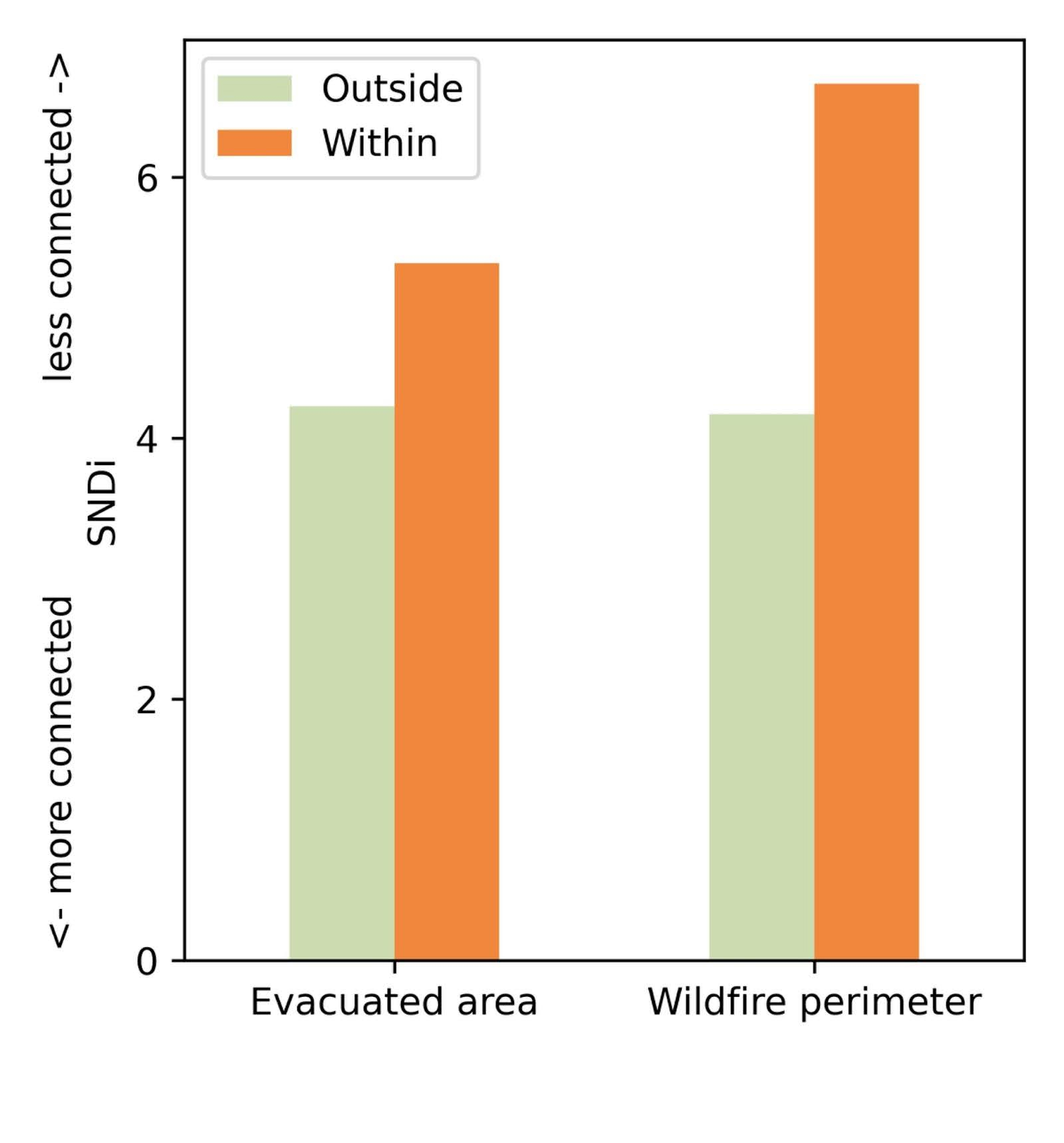
Figure 1. Fire-affected areas in California have lower street connectivity.
Evacuation data are for 2000–2020, based on Heft-Neal et al. 2025. They include evacuation orders (mandatory) and evacuation warnings. Fire perimeter data are for 1878–2024, based on CalFire data.
Figure 2. Street connectivity in California counties.
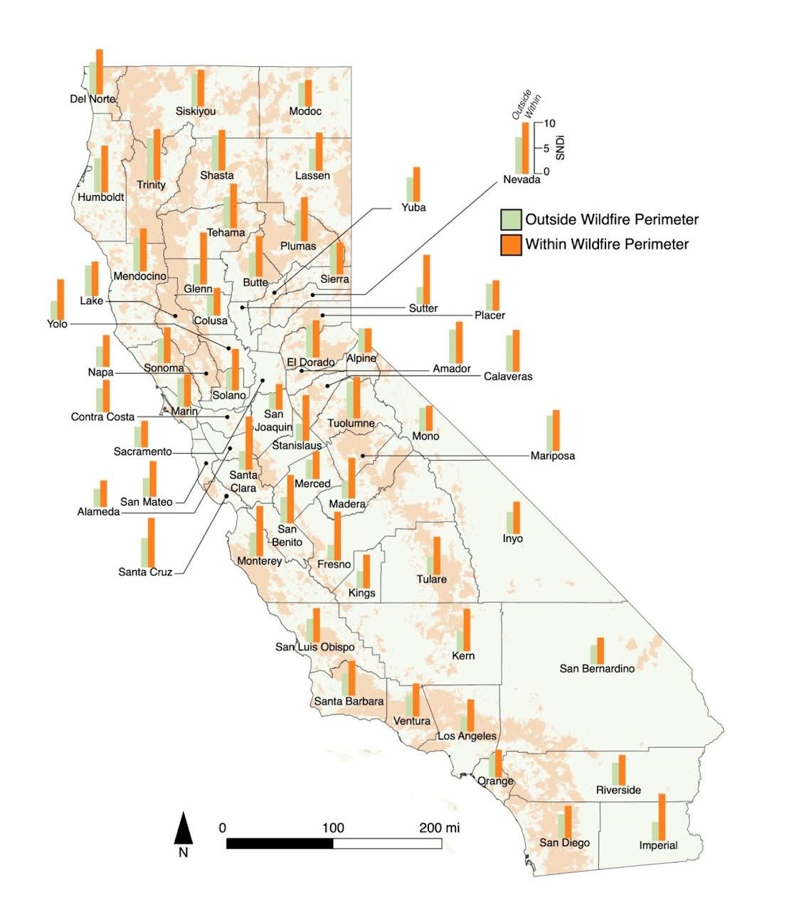
Figure 2. Street connectivity in California counties.
Higher SNDi means less connected streets. Map drawn by Milena Johnson. Data sources are the same as Figure 1.
Street connectivity in new developments has improved in the U.S. and California, but remains low by global standards. Since 2005, new streets in the United States have been built with fewer dead ends and less circuitous routes. However, their connectivity still lags behind that of older U.S. developments (pre-1975), and compares poorly to countries in South America, Europe, and East Asia (Figure 3).
Figure 3. Street connectivity, worldwide.
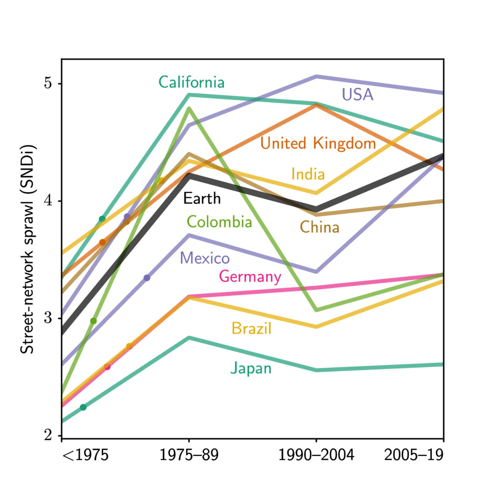
Figure 3. Street connectivity, worldwide.
California and the U.S. have some of the least connected streets in the world. Adapted from Barrington-Leigh and Millard-Ball, 2025.
Japanese cities have some of the most connected streets, even in new suburbs. Rather than a grid, cities such as Tokyo and Osaka feature a more organic mesh of narrow streets with three-way intersections.
Planners can set connectivity standards for streets in new developments. In the U.S., states such as Oregon and cities such as Fort Worth, Texas, Raleigh, North Carolina, and Fort Collins, Colorado, have policies or subdivision regulations that set minimum connectivity levels, require direct pedestrian routes, or discourage or prohibit dead ends.
Beyond shaping the street patterns of new developments, planners can, to some extent, retrofit existing neighborhoods to improve connectivity. Pedestrian cut-throughs can link adjacent cul-de-sacs or connect to neighborhood greenways, as seen in many Danish cities and some California cities like Davis and Irvine. Pathways along flood channels or other infrastructure can connect homes with shops, schools, and services. Where freeways create barriers, cities can build pedestrian bridges and upgrade sidewalks on existing streets that cross the freeway.
More Information
The Street-Network Sprawl Map: https://sprawlmap.org
Christopher Barrington-Leigh and Adam Millard-Ball. 2025. “A high-resolution global time series of street-network sprawl.” Environment and Planning B: Urban Analytics and City Science. https://doi.org/10.1177/23998083241306829
Sam Heft-Neal, Lela Hanson, Atsada Israpanich, and Talia Buckhouse. 2025. Constructing a database of wildfire evacuations in California 2000-2020. https://stanford.edu/~samhn/evacuation-data/
Ayyoob Sharifi. 2019. “Resilient urban forms: A review of literature on streets and street networks.” Building and Environment 147: 171-187. https://doi.org/10.1016/j.buildenv.2018.09.040
Vazquez, F; Millard-Ball, A; and Barrington-Leigh, C (2023), “Urban development and street-network sprawl in Tokyo.” Journal of Urbanism: International Research on Placemaking and Urban Sustainability. https://doi.org/10.1080/17549175.2023.2262698
CITATION
Millard-Ball, A., & Barrington-Leigh, C. (2025). Connected streets promote urban resilience. UCLA Institute of Transportation Studies. https://www.its.ucla.edu/publication/connected-streets-promote-urban-resilience
PROJECT ID: LA2017